Sunday, September 14, 2014

BerryPicker, Hanging Lake, and a Hike with Dad

A few days in Jess and I hiked up Berrypicker trail to the summit of Vail Mountain. We were the only people headed up, it seemed. A crisp 3000ft elevation increase over about 3mi. Moving again felt good. I did not take pictures at the summit due to the fact that the summit of Vail mountain is covered in buildings and lifts. I did, however, take pictures of the journey up, which only lasted 2 hours. It was a joyous time.


This summer has been an unusually wet one in Vail. Rainstorms rolled through for roughly half of the three weeks I spent in the valley, though only a couple days were completely rained out. The storms combined with our lack of a car made traveling a bit rough. Biking and hiking were our sole modes of transport. Luckily the area is full of bike trails and hiking opportunities are literally everywhere.

The second hike of note is the notorious Hanging Lake, which is a short hike (~2mi) up what is basically a staircase. I think the vertical was near 1500ft. The heavily traveled path is well-worn and full of hikers. It is overall a simple hike which leads to a confusingly beautiful location.


Dad flew into Denver two weeks after I got to Vail. Another joyous experience. Jess and I joined him on a hike to Booth Lake, which is north of Vail. The trail head itself is just across the highway from the resort, but due to a crowded parking lot we were forced to park about a mile down the highway and bushwhack our way in. Though we didn't make it all the way to the lake, it was worth the effort. Most activities out there seem to be worth the effort.

So we hiked up a ravine onto a ridge, followed the ridge to it's end, and more or less slid down a slope to the actual trail head. From there we hiked about halfway to our destination before turning around. I have some pictures from there that I can't upload yet. Later.

Overall the Vail Valley is a great place. I will be back. Today I am seated in Denver International Airport on my way to Seattle and Bellingham, WA before heading into the Montana wilderness.

Saturday, September 13, 2014

Leaving Vail

Today we leave Vail to check out Denver and the plains. Tomorrow I hop on a plane to Seattle. The Vail recap is just a draft now, and will be finished on the plane.

Sunday, September 7, 2014

A Formal Apology for My Lethargy!

I feel bad about not posting so much anymore. By this point I assume no one would be checking, but I must push on! I need to get a blurb about the road trip out then I'll move on.  It was nice, but overall uneventful. An 8-hour trip turned into 9.5 when I decided Nebraska was boring me. I turned west into Wyoming. There were no regrets.


Colorado is a pretty cool place. Almost as wonderful a place as they make it out to be. The mountains begin west of Denver. Until then the land is very much the same as what I was familiar with - rolling, endless plains. The Rockies change the scenery rather abruptly. Obviously. From a distance they look like gray clouds. As you approach, the enormous rocks jutting out of the landscape become a bit more intimidating, and then you enter the valley. Towering mountains and cliffs of red, grey, and green surround the valley. The roads are on bridges and mountainsides with steep grades and everyone drives 90mph.

I arrived in perfect time to sit through the closing rush at the shop Jess works at.
Since arriving I have done a lot of relaxing, thus the lack of posts.  The past couple weeks have been spent eating, sleeping, drinking, riding around Vail, and hiking. Also hanging out with Jessy and Eric.

My next post will be about some of the hikes around here. Maybe some day to day too. Who knows. As for now I have bike ride to get out of the way before a hike to Booth Lake.


Wednesday, August 27, 2014

All Things Must Pass

When we last left our hero, he was exploring the Badlands and headed for the hills. Unfortunately this is the place where the journey had to end.

I arrived in Rapid City by 3:00 PM. Drop off time for the rental was 4:00, so I took my time packing up and assembling the bike. I hung around the airport about an hour to wait out the sun and rode downtown to find a place to stay. I found sleep quickly, which was was good.

The next morning marked the start of my march into the Black Hills. My goal of Hill City was only 30 or so miles from Rapid, leading me to believe I would have an easy day. It was definitely easy, but only physically.

Now I'm not sure if I mentioned this earlier (and I don't feel like combing through to check), but I had been having trouble with a few of my middle gears. The trouble being the series of gears would slip due to what was described to me as the "finnicky" nature of 10-speed bikes. It was nothing more than a nuisance throughout the prairie and worsened only slightly into the start of the hills. As the hills grew larger I began to experience more issues, such as the chain popping off when downshifting between certain gears and an increased range of consistently slipping gears. This was bad news - two bike guys at different shops in different cities had explained to me that there was no easy way to fix this issue.

The Black Hills are a different kind of hills than what I had experienced thus far. Elevation ranges from about 3000ft in Rapid City to the 7242ft Mt. Harney, the highest point in South Dakota. The trail behind me hung out in the 1000-2000ft range.

On the outskirts of Rapid City the ride felt odd. There was more resistance than usual. I couldn't pinpoint the issue so I decided it was my legs being weaklings. A short while later the chain slipped. Shift. Slipped again. More slipping. Shift. Pop. Chain's off. Fix, pedal, pop. Fix. Adjust, Shift, shift, pedal. We good? Pop. No.

That was that. My theory is the weight was simply too much for the bike at those grades. The bike is designed for racing. People who race bikes weigh like 160lbs. This thing was not designed to have 230-250lbs sitting on the rear axle. Too much tension on the shifting mechanisms. Keep in mind I have no idea what I'm talking about. It didn't even have mounts for the rack, but it was what I had to work with, and did a damn fine job while it lasted. The nice thing is it works well without all the weight.

By the time I gave in to the inevitable it was too late to get a car. I spent the night in another faceless motel, rode the bike down to the airport, and got a car. And yes, I had to walk the bike up the hill the airport sat on. Only about a 1/2mi though. By noon I was headed out on my now road trip to Colorado.

More later. I'm tired.


Friday, August 22, 2014

To The Badlands!

20Aug

Frustration gripped me on the road back to Eagle Butte. It had been a very slow, draining day. Without the now routine bike ride, I don't think I ever truly woke up.

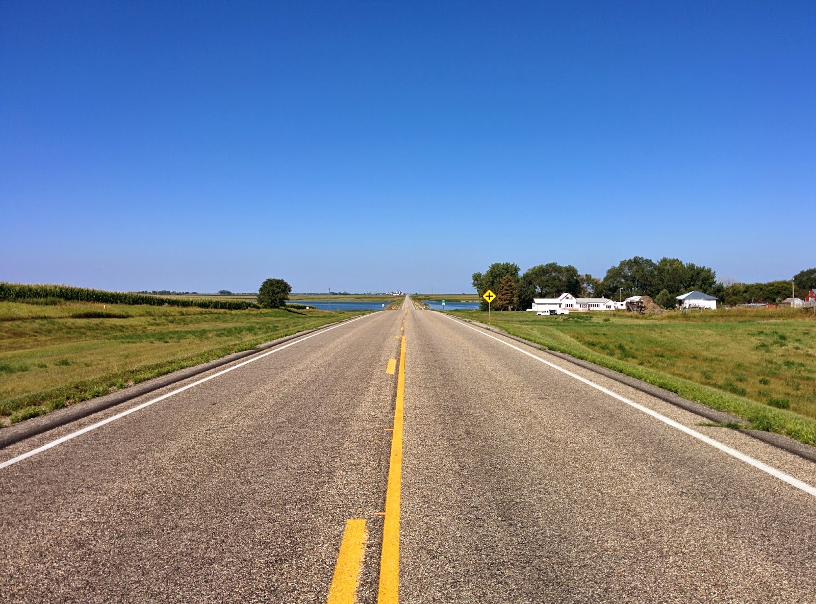
Once I had the bike in the car the frustration was shed. Ahead of me lay miles of prairie, which I would be able to cross in good time for once. The southwestern drive into dusk couldn't have been more relaxing. Although there may have been a few quanta of regret as I explored what would have been my bike route.

Three times I drove the stretch of route 63 today. The third time won the award for most awe inspiring. I had yet to experience sunset on the road here, seeing as one does not want to bike at night. Not a full sunset at least. The idea that I should have ridden a motorcycle, as so many had advised me to, made a lot of sense right then. Seemingly infinite sky - stretching to the almost perceptibly curved horizon - tastefully strewn with enormous fluffy clouds. Each cloud reacts differently to sunlight depending on this factor and that... I'm fairly sure I witnessed all possible combinations.


Heat lightning raged on within a storm system to the north, allowing me to check another cloud formation off today's list. While it never came closer, it never quite disappeared either. Dusk approached as the horizon slowly swallowed sun. The view ahead was still colorful, but growing more dull. Behind me lightning continued to flash erratically.
The large bend that preceded Cottonwood, population 12, turned me west. A hard right onto County Road 8 then sent me south into the nether. Though the prairie is generally desolate, the sense of solitude I felt on this dirt road was well beyond the prairie had offered. Driving through almost complete darkness. Thick fields of tall grass bordering the road, fading into the night. Lightning softly flickering in the rearview mirror like creepy hospital lights in a horror movie. I had to stop the car.

Once the lights on the stupid Focus with all its dumb automatic lights went off, I was treated to one of the most complete summer skies I have ever seen. No artificial light for miles to ruin the view, and ever after those miles there still really isn't too much around. So I stood there and stared for a few minutes, then moved on.

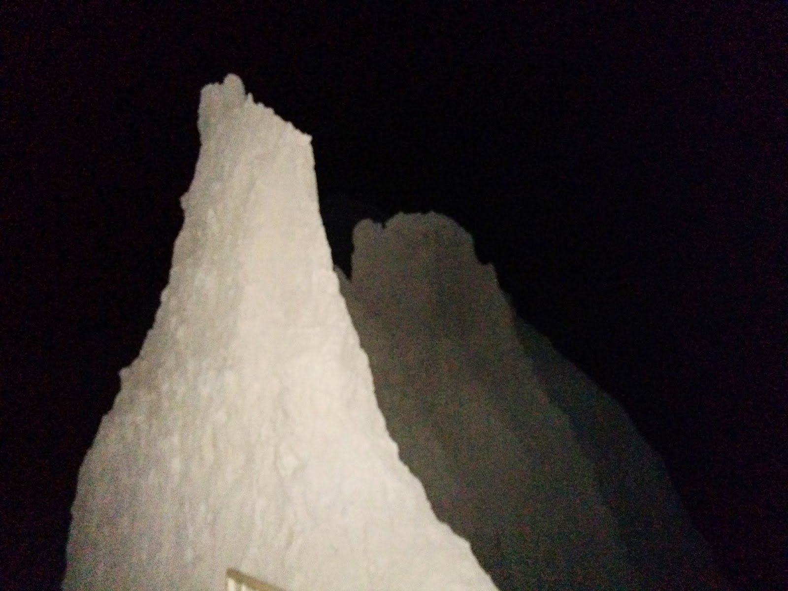
I drove into the Badlands in complete darkness. I hadn't been able to see anything more than a few feet from the road for a while at that point. Expecting to find a parking lot to sleep in, I creeped down the very freshly paved road. A couple minutes in I found a lot to my right, but my focus had shifted to what looked like giant melting anthills in front of me.


I found spot to pull over, got out of the car, and just stood there, staring at these giant silhouettes pressed up against the star filled sky. When the stupor broke I went back to the parking lot. Luckily there were a couple small trails, which I ended up wandering with and without headlamp until 2:00. It's a very strange place at night.


21Aug


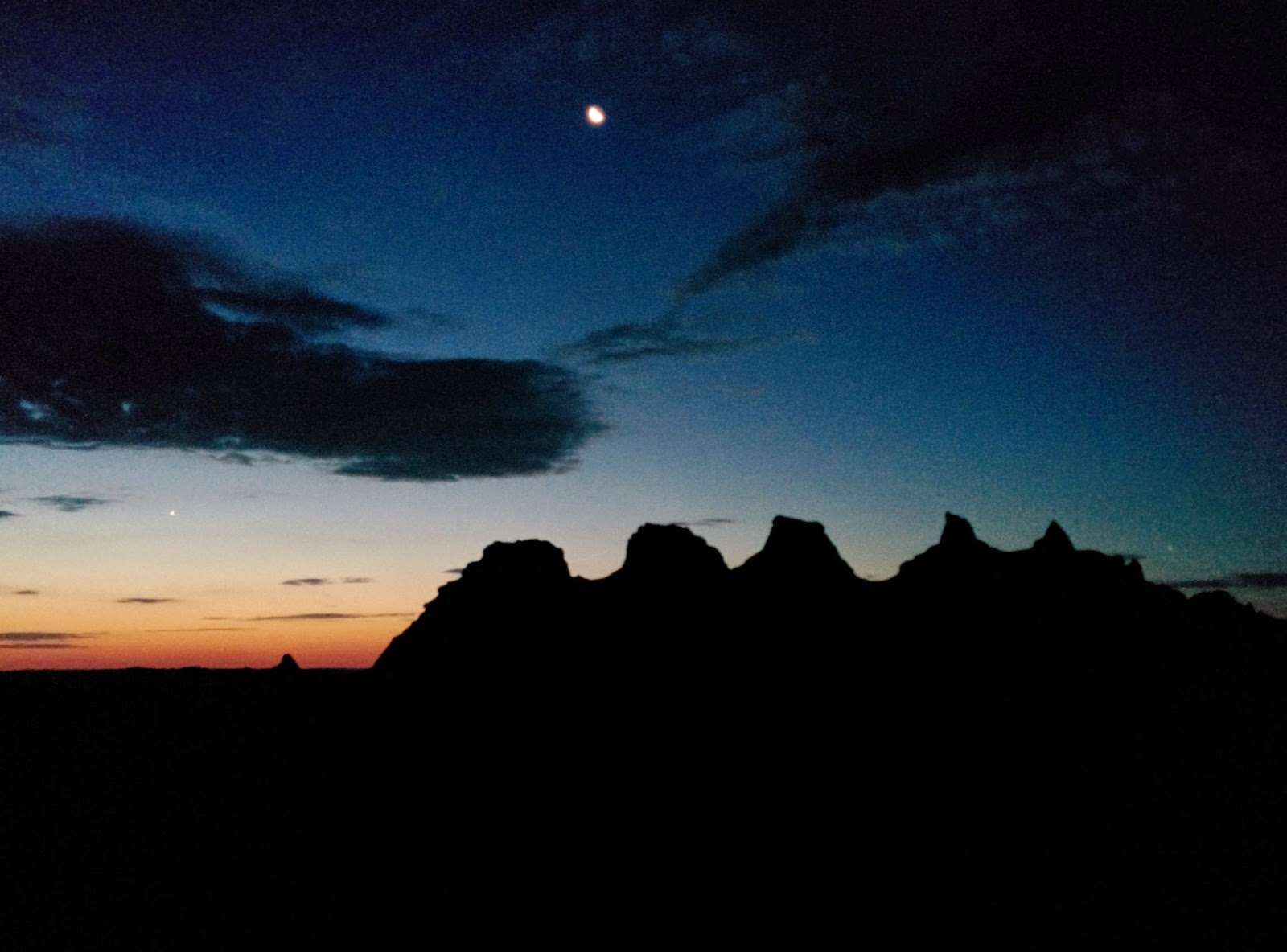
Sleeping in the car was slightly better than expected, meaning I did manage to sleep for some amount of time. My best guess is three hours. The Badlands reinforced a major folly in my planning - an utter lack of suitable hammock trees on the prairie. But I've done worse than a car before. It wasn't terrible.

I was up before sunrise so I hiked in a little ways to get a better view. Until I got that view I really had no idea what I was dealing with. This place is downright strange. At this point I'm going to let some pictures do the talking. I can't think up any more flowery language tonight. I will say, though, that I spent half the day bewildered, staring at most things. It's not a safe place to drive.

The closing scene of this story involves me driving to the Rapid City Airport, eating lunch, putting the bike back together, and riding the bike into town. Then I slept very well seeing as I only got like three hours in that stupid car. Next step is Hill City, then onward to Nebraska.


Wednesday, August 20, 2014

I Cheated

And I'm definitely paying for it.

The trip to Eagle Butte taught me three things: the prairie is beautiful, the prairie is unforgiving, and the prairie gets boring fast. In order to make up for some lost time, and to avoid pedaling into the 85°F wind, I have decided to cheat.

I shuttled out of Eagle Butte towards Pierre. There awaited a car in which I was to drive to Rapid City. Fittingly, it takes more work to leave Eagle Butte this way than it would have been had I just rode.

Exhibit A: I was supposed to leave yesterday morning. The ride was canceled last minute. 

Exhibit B: I was told my bike would fit in the shuttle. False - it does not. I had to leave it at the hotel, therefore I had to return to Eagle Butte prior to continuing on to Rapid City.

Exhibit C: Halfway into our trip to Pierre, the other passenger realized he was going to be late for his appointment... so we turned around. Had I been driving I would not have been so kind.

Exhibit D: Busses regularly leave Pierre for Rapid City. They will not, however, transport my bicycle. Thus the need for a rental car.

The bottom line here is that I am bypassing the badlands, though I will be driving through. I realize I am not prepared to camp in these areas, partially due to lack of proper experience, and a bit because hammock camping is not feasible out here. Seeing as I made it almost 600mi and am behind schedule, I'm happy with the plan.

After arriving in Rapid City, I will head south to Hill City. That's the area where you'll find them there monuments. From there it's more south on the Mickelson Trail through the hills and into Nebraska. I aim to arrive at the finish line by Aug 30.

Tuesday, August 19, 2014

Little Trek on the Prairie

17Aug

Against my better judgment I crossed back into the hills. Timber Lake is southwest of Mobridge. More west than south. As I said before, crossing the river is a sight. The hills sure do grow quickly west of the the Missouri. Big, rolling hills.


After conquering the first hill - on which a sub-par casino lies - I glanced at the path down the other side and hesitated. Again that 'what am I doing' feeling cropped up, and again I had to ignore it. Mainly because I had no place else to go.

That was the day I realized my legs actually possessed a small amount of strength. And damn did I need it. I got lucky with the wind. The sun and the hills, however, set me up for a two hour nap under a small tree at the end of a driveway. The only shade in quite some time. I woke up, ate a snickers, and started into the last 15 or so miles of the trip. Within an amount of minutes I realized my extended sleep session had set me up to pedal directly toward a terrible giant undulating black cloud. Seriously, the thing looked like it was flowing.


In a mad dash, I made it to within 4mi of Timber Lake before my terror drove me to pull into a truck shop yard and hide under my tarp. Just after the storm broke, a man named Tim Bollinger, owner of aforementioned shop, pulled up and offered me shelter from the storm. Also a beer.

It was quite the storm - 1/2in of rain in about 10min, with all the wind and lightning anyone could ask for. The storm continued, and Tim offered me a ride into town. I happily struggled to get the 60-odd pounds of muddy bike and cargo into the truck bed and hopped in the cab. Dude helped me find food and a place to stay. Good man, that Tim Bollinger.


Aug18

I once again sat for a bit in the morning attempting to figure out my next step. I settled on Eagle Butte as the destination. Eagle Butte is more southwest. This time more south than west. After a patty melt and fries breakfast I hit the road.

Western wind that day, maybe just a tad to the north side. Good thing the first 7 and final 4 miles were directly west. Combined those short sections took me about 90min, roughly 50% longer then normal... at least the wind kept me cool.

Turning south felt just wonderful. The hills picked up and the desolation picked up a bit more. Even got to see some up-close buttes. I managed to find an oasis a half-acre into a ranch around 2:00pm. I've found its hottest out here between 2:00 and 6:00, so I did the right thing by trespassing just a little and having a trail mix lunch and a nap under the trees. I was also able to befriend a butterfly. Really though, it sucked sweat out of my drying bandana like nobody's business.


I hit the road just a tad too early - sometime around 4:00 - and it was hot. Like 90°F, with very little cloud cover. I should have stayed longer but I was getting hungry and didn't really want to stomach more trail mix at the moment (I ate a lot). So I left.

20mi can feel a lot longer when pedaling in the beating sun. I grew weary after a bit and found shade again. This time next to a stack of hay bales. Shorter break this time, had a snickers, hit the road. Finally on the horizon I see water towers. The fact that I could see them meant they were about 10mi away.

A half hour later I was at a junction 4mi from Eagle Butte. Remember that wind? The road to town heads directly west. The wind decided to give me one final challenge. Those last 4mi took me almost 45min. Even going downhill I needed to pedal if I wanted to gain ground. Not that the town is downhill - it lies on the Fox Ridge. The prairie is quite the monster. I admit I did not expect such extremes in this place, though I guess some of the the locals did try to warn me. It's been good fun.


Monday, August 18, 2014

...Data

I'll be updating less frequently due to data usage restrictions. This will most likely be when I get to a place with free Wi-Fi.

I promise I did stuff yesterday, you'll just have to wait to find out what.

Saturday, August 16, 2014

Wakpala Powwow


A foggy morning gave me an excellent excuse to sit on the curb and debate my next move. Do I go south? Do I cross at Mobridge? What do I do from there? The fog lifted around 10:30, and I headed west.

It was a mildly windy day (though out here it isn't wind until it's 60mph. One guy told me South Dakotans can't stand up without wind) but I managed to make it to the Wakpala Wacipi (powwow) on the Sioux Standing Rock Reservation by mid afternoon. I hung out, talked to some folks, and enjoyed the show. I really enjoyed the music. Their singing style is incredible, and the hand drum driven beat is raw and excellent. I got some video. I wish I could have recorded it better.

This kid is legit


I'm embarrassed by the video quality but I'm assuming y'all wanna see it.

It felt good to cross the great Missouri River. WOOO! It is just plain beautiful. The river is enormous up here - the government dammed it up in the 1940s. They call it Lake Oahe. It's a very controversial dam due to how badly it affected Sioux lands, but you can't deny the beauty - the sun in an endless sky shining down on the massive river, green and amber hills rolling across the landscape, and the silhouettes of buttes looming in the distance. It the first time I've seen anything in the distance other than a farm in a long time.

Around dinner time I decided to head back toward town for food. Wakpala is about 7mi NW of Mobridge. Lucky for me it was 7mi downwind. Unlucky for me though, is the lack of trees out here. The hills were not made for hammock camping, I'll tell you hwhat. So I had to cross back to the east side. I'm in a motel in Mobridge. Headed back across the river to Timber Lake tomorrow.


Friday, August 15, 2014

Another shakedown

Aug 15

There I was standing at Mr Bobb's Drive-Thru, considering my fried lunch options. I caught a glimpse of the family as they stared at me - the confused looking guy in spandex pants. They asked where I was headed. When I told them they looked at me even more crazy-like.
Apparently crossing this bridge up here scares a lot of people. These folks seemed to think the Indians are the major concern. The two counties just west of the river are reservation land, and I'm not sure if it's actual experience or old racism that these people are feeding me.

So about 20mi from the bridge I am once again halted. I called my contact in Mobridge to get his opinion on the matter. I don't know this guy. Bartender Dave gave me his friends number who in turn gave me another guys number. So I call guy #3 and he tells me to go south first - don't even go to Mobridge. His reasons were more that of heat and hills, Back to the maps.

It was late enough by that point that I wasn't going anywhere so I got a motel room and headed to the bar for food. The folks at this bar told me the others are crazy for being scared, and that there is a powwow this weekend just the other side of the bridge.

Now I'm in a predicament: do I ride 30mi to a powwow (in the home of Sitting Bull), likely meaning I will have to turn around and cross back over before heading south, or do I just go south?

I'm thinking powwow, and deep down I'm hoping someone heading south from there will let me join them. I want to ride the west hills badly, but I know I'm wholly unprepared, and I don't feel like dying of thirst this week. I am also kinda tired of the endless farmland that is eastern South Dakota. It's boring me now. I'll let you know what happens. Either way I hope to be in the Black Hills by next weekend.

I didn't take any pictures of scenery so here are 2 pictures of my haggard tarp structure. The rain wasn't terrible, but the wind was, and this kept me nice and dry. 


Thursday, August 14, 2014

It's so sad

The hammock is up, the tarp is up with extra trash bag protection, and I'm sitting in a Porta potty with a headlamp and a book because of the lightning :/


Friendly Warnings

Today was an exceptionally nice riding day. I rode a total of 61mi to the town of Bowdle, where I am currently camping at the city park... really really hoping it doesn't rain.

I left Aberdeen around 9. The skies were overcast after a night of periodic storms. It remained overcast the bulk of the day, AND, with the wind blowing from the southeast (remember - I'm heading west) things were good. I took a nap in a park, had a staring contest with a herd of cattle, and got free food from some bikers who pulled me over to offer me free food.


I headed to the gas station when I got to town because, like in many of these towns, the gas station is the only food spot available. There I was questioned thoroughly by a pack of elderly folk. They are not too happy about my new route. Desolation, heat, rattlesnakes, and lack of water were discussed. I'd be lying if I said they didn't scare me some. So I'm gonna look into that again. Next stop is still Mobridge. I'll figure out what to do there. Maybe I can get some tubes and float myself and my bike down river. No issues finding water there. I believe that'll keep the rattlesnakes away too.


Wednesday, August 13, 2014

Aberdeen is still nice

I didn't do much today. After deciding to change routes yesterday, I hung around to plan my new route carefully and prepare for multiple days of isolation west of the Missouri river (by overeating). The planning involved more conversation with Dave, which led to the disclosure of important details, like the laser light show at the Crazy Horse monument, and the old timey train that runs from Hill City to Keystone.

After lunch I watched too much of a bad movie before heading downtown to the bike shop. There are no bike shops between here and Rapid City, 330mi away, so I had the bike checked out. I also talked routes with the guy at the shop and got some new fancy padded bike pants so my butt don't hurt so much. God I hope they work.

Tomorrow I head west on rt12 toward Mobridge. According to the locals it's exactly 100mi. I haven't confirmed that on the internet yet. The plan is to cross the Missouri River at Mobridge and head south through what looks like the literal middle of nowhere en route to the badlands - the actual literal middle of nowhere.


Tuesday, August 12, 2014

Aberdeen

As I sat warming in the morning sun I wondered to myself "have I made a mistake?" Most of my trail mix was gone and I was still hungry. I had about 1.5L liquid in Gatorade and water forms. Only 34mi ahead of me but I was still concerned. Then I saw a flash of green - a woman had just walked out of what I though was an abandoned building and put up an "open" sign. So I walked in and asked if they had food. They had biscuits and gravy. Mmm.
The spot was a gathering place for local truck drivers and farmers. I chatted with the group about how I'm crazy while I finished my breakfast. Just about routine conversation by now. Then I refilled my water and hit the road.


The trek was more arduous than I expected. Seeing as the wind had been blowing from the northwest, I figured I had 15mi of headwinds followed by 20 easy miles after I turned south. Nah. Southwestern wind today.  And the sky was cloudless, which while beautiful, meant I was in the sun for the entire ride. So that was kinda exhausting, but I got to Aberdeen sometime early in the afternoon and went to the first hotel I saw. Then I got a room, showered, and ate way too much.


At the bar I met Dave, the "best bartender in three states and two Canadian provinces" according to his friend. Dave is a good dude. He informed me of some unfortunate and route-changing news involving the road that leaves Pierre toward the badlands. It's closed. After a lot of consulting with Dave I found two alternative routes. One would actually bypass the badlands by heading to Sturgis from the north. I would then have to double back after funneling south through the black hills. The other would bring me into the badlands but may add lots of miles. I gotta do the math still. For now I need to recover from how much I just I ate. That was a huge mistake.